
Urban density and the promises of proximity
As an economist, an end of year tradition is to muse over The Royal Society of Statistics, ‘Statistic of the Year’. In 2018, the singled out stat was: 90.5% - the proportion of plastic waste that has never been recycled. An important statistic, but an area in which the International Growth Centre’s (IGC) ‘Cities that Work’ initiative has limited knowledge.
Therefore, a hark back to 2017’s statistic of the year is necessary: Only 0.1% of the United Kingdom (UK) is ‘densely built upon’. This is low relative to most expectations, particularly when one considers that 71 times more of the Monarch’s land is peat bog (The Crown is the largest owner of all land in England and Wales).
Measuring urban density
Being classified as ‘densely built upon,’ as per the Royal Society’s definition, requires the land to be seen as ‘continuous urban fabric,’ i.e. 80% being covered by artificial surfaces. Again, a low amount by expectations. However, density, as pursued in the research synthesised by Cities that Work and advocated by urban planners across the world, has a different measurement: One in which compact urban form allows numerous complex social and economic interactions – more than just artificial surfaces.
Unfortunately, this view of density is often mis-conceptualised, mis-measured, and missed altogether. A lack of consensus on what should be dense and how it is measured represents a difficulty for urban policymakers.
The benefits and challenges of dense cities
The benefits of density are long lived. In 1785, ‘A Dictionary of the English Language’ author, Samuel Johnson, remarked ‘men, thinly scattered, make a shift, but a bad shift, without many things…it is being concentrated which produces convenience’. In other words, proximity of men (and women) can produce prosperity. This convenience was initially required to have enough footfall to support cultural facilities. Since 1785, the concept has grown and environmental and economic density benefits are regularly outlined.
Critical for emerging cities, urban density provides the clearest path from poverty to prosperity. In particular, this is because urban areas benefit from both scale and specialisation. This means workers are better matched with jobs, seeing higher wages. Agglomeration mechanisms enhance productivity and compact space means more effective public transport with less private vehicle’s carbon emissions.
In the past fifty years alone, the strong correlation between urbanisation and income, has been driven by increased density, over and above the idea that cities attract more talented people. Yet, there are also downsides to density, namely contagion, crime and congestion. These downsides can constrain city development. However, through well-functioning governments with sufficient expenditure, they can be contained. This centrality of density for urban development has made it a buzzword of our time, with many urban policymakers around the world trying to pursue it.
Mis-conceptualised & mis-measured density
Regrettably, however, the clarity on what density to pursue is lacking. Density is often calculated as people per hectare, which is a measure associated with residence. This is often seen as important for both financially efficient public transport systems and low commuter pollution.
One example of density’s importance for city transit networks is its necessity for Bus Rapid Transit (BRT) systems to become financially viable. Evidence has shown that on average, BRTs should have at least 10 passengers boarding per kilometre per bus to be financially viable. However, this is a requirement that only dense neighbourhoods can deliver.
This push for the densification of neighbourhoods has led to the creation and advocation of precarious normative targets, such as between 150 to 450 people per hectare or 30 to 90 dwelling units per hectare, without any further qualifications. This type of measure is useful in ensuring efficient transport orientated development. However, the unparalleled knowledge flows and spill-overs that come from agglomerated and clustered commercial districts require a different attention.
The promises of proximity: Floor area ratio
These targets, unfortunately, disregard the key benefit of density, which is that of face to face contact and urban buzz – the productivity gains from regular interaction and cooperation with similar minded people. Proximity of these groups and their networks results from proximity of places of work. Subsequently, these commercial density benefits in comparison to residential density are central to the coordination of the economy.
‘Smart people being around other smart people’ allows ideas to flow, ultimately driving economic growth. The City of London exemplifies this: A lowly 32 people per hectare in its residential density still provides 3% of the UK’s national income. Therefore, when pursuing density, policymakers should cautiously regard the measure of people per hectare and think about density in its entirety: Both in terms of residential and commercial variables.
A useful alternative density measure is floor area ratio (FAR) (building coverage x building height). Certain average dwelling sizes or office space assumptions are required, but this measure better captures both the benefits derived from residential, commercial and mixed use districts. It also produces an easier comparison between cities.
The skyscraper skyline of Manhattan’s 265 people per hectare, is tricky to compare to the more traditional city pattern of Manilla’s 430 people per hectare. In contrast, with FAR, the comparison between cities, as seen with Washington DC and Kampala in IGC’s taxing vacant urban land paper, paints a clearer picture. This is with the caveat low and middle income cities don’t start building super skinny skyscrapers anytime soon – which would send FAR rates through the roof!
Furthermore, with FAR, no matter the building height or compactness of a district – density, with its devils and desires, becomes apparent. Whether it be congestion or connectivity, FAR makes a useful indicator of whether a city’s citizens are harnessing the benefits of proximity.
The pursuit of density versus urban sprawl
Even with the benefits of density being known and widely touted, there are many places where the opportunities to densify development have been missed. Illustrating this is the fact that globally, population density in urban areas declined by 1.5% between 2000-2013. This is sometimes due to an un-planned and un-coordinated response to high urban population growth. However, inherited colonial laws have often underpinned difficult legislative decisions. The planning for towns of the United Kingdom in 1947 are not applicable for cities of Africa 70 years post.
Some of these laws place density regulations, capping the quantity of property per plot and reducing population density. Often regulations are over stringent: The accepted FAR in Delhi, India is 2, compared to 15 in Manhattan, the United States. In Bangalore, India, lifting such restrictions would result in a 17% reduction in city size, seeing commuting costs reduce and savings increase by between 1.5% and 4.5% of earnings. In many cases, these regulations result in sprawl.
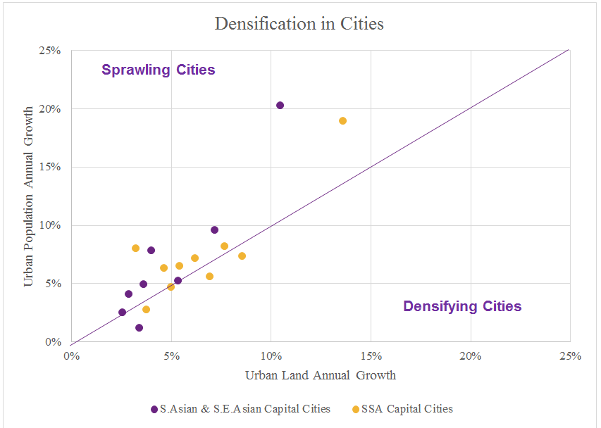 Figure1
This is the case in both sub-Saharan African cities and those in South and South East Asia (Figure 1).
Recommendations
City policymakers therefore need to reassess how they can reverse the trend of cities sprawling. But in doing so, not unquestioningly chase ‘continuous urban fabric’ or unqualified statistics of people per hectare. Instead, urban policy makers need to use the evidence available and pursue what is right for the particular neighbourhood they are planning on developing.
In many cases, this will require a re-focus on the knowledge and human capital spill-overs that come with the clustering of firms. In all cases, ensuring central city land is able to be used efficiently and intensively is key. FAR is a good way of ensuring this – no matter the building’s use. With this at the forefront of policymaker’s minds, the benefits of density can once again reign over cities.
References:
Collier, P., Glaeser, E., Venables, T., Blake, M. and Manwaring, P. (2017). Secure, legally enforceable and marketable land rights for urban development, Cities that Work, the International Growth Centre. Accessible: https://www.theigc.org/wp-content/uploads/2017/08/Secure-legally-enforceable-and-marketable-land-rights-for-urban-development.pdf
Collier, P., Glaeser, E., Venables, T., Manwaring, P and Blake, M. (2018). Accessing opportunities: Policy decisions for enhancing urban mobility, Cities that Work, the International Growth Centre. Accessible: https://www.theigc.org/wp-content/uploads/2018/05/Accessibility-04.05.18.pdf
Glaeser, E. and Dempster, H. (2015). Contagion, crime, and congestion: Overcoming the downsides of density, Growth Brief, the International Growth Centre. Accessible: https://www.theigc.org/reader/contagion-crime-and-congestion-overcoming-the-downsides-of-density/
Haas, A. and Kopanyi, M. (2018). Taxing vacant urban land in Kampala, Working paper: C-43407-UGA-1, Cities that Work, the International Growth Centre. Accessible: https://www.theigc.org/wp-content/uploads/2018/08/Haas-and-Kopanyi-2018-working-paper.pdf