
Data for decision-making: How spatial data is shaping the African urbanisation story
Ahead of the 17th Urban Age Conference and the first to be held in Africa, Sebastian Kriticos and Astrid Haas discuss the need for better data to tackle some of Africa’s biggest urbanisation challenges.
On a daily basis, city policymakers need to take decisions: where and how to deliver services, what rates to apply to taxes and where to make investments, amongst others. However, in many African contexts, they are doing this in the absence of accurate and timely information at a very local level. As a result of this lack of data, it is practically impossible to get a good sense of where and how people live and work, and ultimately how best to allocate their very scarce resources. This is a particularly acute challenge in the African context where there is the constant struggle to adequately service both the existing city as well as the rapidly growing populations.
The data challenge
To date, a great deal of our knowledge on urban Africa comes from household and firm surveys, often collected by the national statistical agencies of countries. Although these are a helpful starting point, they can be burdened with major challenges, including representativeness, frequency, and of course, availability. For example, making a survey representative requires an up-to-date sample frame from a national census. However, these are few and far between in developing nations: only 12 of the 46 countries in sub-Saharan Africa have held a census in the past decade.[1] Therefore, solely relying on these sources of data to understand and improve policy making is far from sufficient.
A further issue is that methodologies for data collection can vary widely across countries. For example, there are multiple different approaches to define where a city begins and ends both across countries, and even between cities within the same countries. This has implications for generating a common understanding on the reach and boundaries of cities and such methods influence even the simplest of research and policy questions and significantly challenge our ability to do cross-country comparisons.
The future of urban data
Gathering more data is undoubtedly a key part of the answer but it can come at the cost of large-scale investments. That said, as our technologies advance, there are increasingly innovative and exciting ways of studying the urban environment appearing. Remote-sensing data is a clear example: its greater availability and use over the past decade has provided us powerful new ways to understand and track human activity across our world. In particular, cities research has benefitted from it as it can be used to track the growth and sprawl of cities as well as finer details, such as the location of informal settlements.
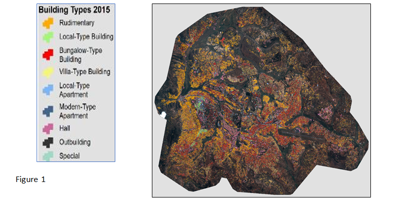
Geographic Information System (GIS) platforms have become integral complementary tools to harness the power of spatial data. A recent example of this is work done by Bachofer and Murray (2018) which combines satellite and socio-economic data to study housing supply in Kigali. Figure 1 shows the building footprint and types across Kigali, demonstrating the fine level of detail that can come from GIS work, as well as the wide range of applications that could be useful to government.
[1] https://international.ipums.org/international-action/samples
As mobile phones become increasingly prevalent and available throughout the developing world, data from them, including call data records (CDR), can provide us high volumes of very timely information on individuals. Through this so-called Big Data we are much better placed, for example, to track collective urban mobility, how citizens connect with spatial amenities across the city, and how transport systems could be improved. Duranton and co-authors, for example, are using this data to estimate the welfare loss from congestion across cities in Colombia and India. Blumenstock et al (2017) used CDR data in Colombo Sri Lanka to measure the impact of an investment in a super highway on commuter’s travel patterns.
Although these are important foundations for new research opportunities going forwards, there are challenges in accessing this data in many countries, as it belongs to private telecoms companies and even when it can be accessed, it can be difficult to analyse. Most importantly, however, in most cases it will have to be calibrated with surveys to allow for concrete conclusions to be drawn.
Bridging the divide
Overall, these improvements in economic research and data are consistently enhancing our understanding of what shapes the urbanisation process. However, as noted, there are often significant challenges in bringing these findings to bear on policies and practices that could improve outcomes. Effectively bridging the gap requires a different approach, namely working to get policymakers clear, consistent, and credible information to guide their decisions.
A powerful approach to this is being undertaken by LSE Cities: they have assembled a broad range of comparative data from a number of different sources on how global cities perform across key spatial, social, economic, and environmental indicators. Their visual information, as seen in Figure 2, is easily accessible to policymakers, allowing them to assess performance against other well-known cities, and helping to ensure the results are transparent and actionable. Recently, LSE Cities have started providing this type of information for African cities, the first results of which will be showcased in the forthcoming Urban Age conference, in Addis Ababa.
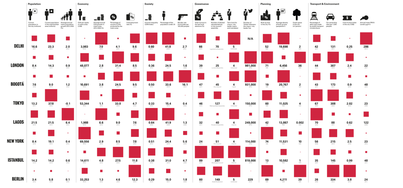 Figure 2
Bringing it all together
A further key factor is that cities in developing countries themselves could do much more to collect as well as coordinate and share data across different institutions. One example is the City of Cape Town that is pioneering efforts on the continent by introducing a dedicated research and data strategy to improve evidence-based decision making for the city. The aim of these strategies is both to ensure that they are making the most of the stock of data they already have, as well as identifying important data gaps and how to resolve these.
Accurate data that decision-makers can trust and understand, will help us build the policy narrative around African cities in a way that is more reflective of the reality at hand. It will both support research that can take place around urbanisation on the continent, and more importantly, it will support the daily decisions that policymakers in allocating their scarce resources. Although we have made and continue to make tremendous progress, there is still some way to go. Therefore, working towards improved means of collecting, using, and disseminating both existing and new data sources should be a cornerstone of the African urbanisation agenda.