Mapping informal settlements in Lusaka
Project in collaboration with Ordnance Survey (OS) and the Commonwealth Association of Architects (CAA) seeking to respond to challenges associated with urban growth by piloting the creation of an automated digital base map of Lusaka, Zambia.
The IGC has been working with UN-Habitat to support the Zambia Ministry of Local Government. This has demonstrated, as re-emphasised by the COVID-19 pandemic, the need for a better understanding of the city’s informal settlements.
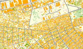
A collaboration with Ordnance Survey (OS) and the Commonwealth Association of Architects (CAA) has set out to respond to the issue of insufficient spatial data, by piloting the creation of an automated base map of Lusaka, focussing on the identification of informal settlements. Currently, the base mapping in Zambia is not sufficiently up to date to provide a meaningful spatial data infrastructure foundation. Using aerial imagery of Lusaka, OS is trialling its advanced automated process to generate a new base map, a faster and more resource efficient process than traditional methods.
You can explore the base map below or by clicking here.
You are granted a non-exclusive, royalty free revocable licence solely to view the licensed data for non-commercial purposes for the period during which Ordnance Survey makes it available; You are not permitted to copy, sub-license, distribute, sell or otherwise make available the licensed data to third parties in any form; and third party rights to enforce the terms of this licence shall be reserved to OS.
The base map provides data regarding:
- Identifying and locating informal settlements, their size, and the number of built structures;
- How the formal and informal neighbourhoods are served by roads and public spaces;
- Assessing the density of population based upon the number of buildings;
It also provides a robust foundation for the integration of future census data and for a range of other functions including land administration. Together, this can enable the Ministry to better target investment in critical infrastructure and services, upgrading informal settlements in order to provide for the most vulnerable city residents. It can also assist in better planning for urban expansion, which reduces the overall cost of infrastructure investment, limits informality, and enables more resilient and sustainable urban futures. This process has the potential of producing a base map quickly and efficiently, at a time when accurate population and settlement data is critical.
If you have any questions about this project or would like access to the shapefiles related to the map please contact [email protected].


