Evaluating economic gains to urban investments and policies: Introducing IGC’s Cities Spatial Model
The IGC, in collaboration with researchers from the World Bank and policymakers from the City of Cape Town, has created an R package - IGC.CSM - to model the economic impacts of urban interventions such as new roads, bus systems, or planning regulations. It shows how these policies or investments will affect where people will live and work, how housing prices and wages might change, as well as the overall welfare implications. With minimal requirements for data inputs or programming knowledge, it aims to equip policymakers to incorporate such insights into their decision-making process.
How large are the economic gains to improving public transit systems within cities? Which areas of the city will become denser? Will property prices rise? Will certain parts of the city become more productive? Will certain sectors benefit more? Which areas of the city will lose? Will this reduce or increase inequality?
Policymakers in cities around the world grapple with these question while allocating scarce municipal budgets to infrastructure and services. Their decisions can have large and long-lasting implications for the spatial form of the city, its residents, and its economy.
Structural spatial models have made progress in providing insights on these questions. The simplest version of these models allows each location in a city to differ in terms of its productivity, amenities, density of development, and access to transit infrastructure. Additionally, it can identify how trade, commuting, and the influence of neighbouring residential areas or production areas shape the structure of a city.
Can structural modelling help inform policy decisions?
Several researchers have since used similar models to assess changes in the spatial organisation of economic activity in a city in response to specific policy interventions – such as a change in the transport network or new land use regulations.
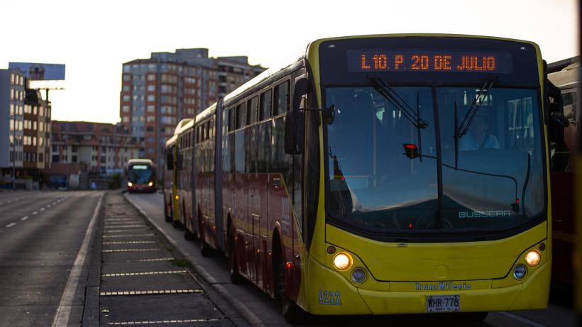
For example, the world’s largest Bus Rapid Transit (BRT) – the TransMilenio in Bogota. Here, the model used distinguishes between high- and low-skill workers to comment on how the BRT impacted inequality in the city, and assesses how land value capture tools might have altered the outcomes had they been implemented at the same time.
The model shows that the BRT’s impact on welfare and productivity exceeds the cost invested, but with high-skilled workers benefiting more. However, had the government increased the permitted densities by selling development rights in areas where market access improved because of the BRT, the welfare gains would have been 23% larger, and the government could have raised enough money to cover 18% of the construction costs. Low-income workers also benefit more in this scenario.
In Kampala, the impact of land tenure systems on land-use patterns and economic activity in the city was explored. It shows the traditional land tenure system – mailo – brings benefits to residents in terms of amenities and rent caps. If all mailo land was converted to leasehold, mailo residents would experience a loss in this amenity, but overall urban productivity would rise due to more efficient land use. The increase in urban wages would be between 2- 6.7% and would be highest for low-skill groups.
In India, a similar model was used to look at the spillovers from high-rise developments on slum residents. It shows that while the increased supply of housing and commercial floorspace increase welfare overall, the residents who are evicted and compensated are 24% worse off, and if not compensated, 35% worse off. On the contrary, those living in slums that are not re-developed are 8% better off. Compensation therefore needs to be three-times greater to avoid worsening inequalities.
Researchers from the World Bank have also used these models to investigate the productivity and welfare implications of transport improvements. A BRT line that improves connections in the Greater Amman Municipality has been found to increase output by between 4-7% with the greatest benefits observed for manufacturing workers residing farther from the city centre. Similarly, in Mexico the introduction of new subway lines has led to a reduction in informality among workers.
The IGC’s Cities Spatial Model (CSM) package
To aid policymakers facing a dearth of information to support these infrastructure and policy decisions, the IGC has created a package in R (available for download on the CRAN repository) that operationalises these structural models in a user-friendly way. It aims to put the power of these models in the hands of policymakers in cities across the world, enabling them to apply this framework to several different policy questions - with minimal data inputs and minimal programming knowledge.
The current iteration of the package represents the model in its simplest form. This simplification ensures the package’s applicability even in data-scarce environments, while still reliably ranking policy options. Where relevant additional data is available, the package can be extended to incorporate these features.
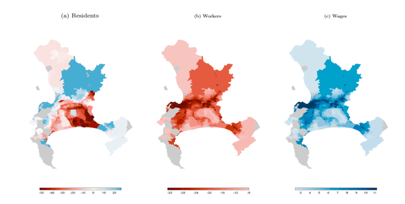
The first application was conducted in Cape Town – evaluating the Phase 2A extension of the MyCiti bus route. Figure 1 shows the change in where people live, where they work, and the wages they are able to earn in each location. Overall, the welfare gained from the MyCiti BRT line is 1.52%, or in currency terms, an average resident would need around US$ 103 additional annual income to experience the same benefit.
Figure 1: Simulation of impacts from implementing Phase 2A of the MyCiti BRT

Notes: The figure shows the changes in where people live, work, and how much they are able to earn after the introduction of the MyCiti BRT in Cape Town. The BRT led to a welfare gain of 1.52%.
Conclusion
Policymakers in cities in developing countries face challenging decisions on how to allocate their budgets to provide the infrastructure and services that will maximise urban productivity, as well as their resident’s quality of life. These include decisions around BRT investments, land value capture, density restrictions, land tenure systems, and slum resettlement. Such decisions will impact urban form for generations to come, and it is therefore imperative that policymakers are equipped with the right information.
The IGC.CSM package in R can be used alongside other models and knowledge tools to inform these decisions. Through simulation, policymakers can discern which policies or projects yield the highest economic returns, balancing these benefits against construction and operational costs.
To learn more about the new package, read Cities Spatial Model: A Quantitative Spatial Equilibrium Model to guide urban planning, policy, and infrastructure investment decisions.
The 8th Urbanisation and Poverty Reduction Conference will be held on 7 and 8 March 2024.

